Sunday, April 20, 2008

Walkers Follow Ridge

I was just thinking how well marked this section of trail was when I got lost. Just a little lost though, looking at my map and interpreting the contour lines I walked on, following the ridge line, soon passing another marker which stated "Walkers Follow Ridge". But sure enough, yup, I soon lost the trail.

Woolshed Flat to Quorn to The Dutchmans Stern
Northern Guidebook, Maps 3.8-4.2

Frankly, "Walkers Follow Ridge" sounds easier said than done. I mean, all well and good, but one needs to keep a good lookout for the marker that is going to lead you off the ridge. I found this one, but even though there were now lots of markers to lead me down into Pichi Richi Pass, there weren't quite enough for me (or I was too stupid for how few markers there were?). I soon got lost, the trail indistinguishable from the rocky landscape. Although, a fairly good spot to get lost, lots of distinct landmarks: Pichi Richi Pass on one side, containing a road and railway and a couple of distinct dirt roads, and Devils Peak and Mt Brown beyond. And I had my GPS, true. But lost I got, I knew where I needed to be and figured at some point I would wander across the trail and see it again, which of course I didn't. I found the trail again when it met up with railway.
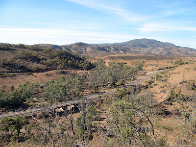

Pichi Richi Pass with Mt Brown beyond

I was doing a catch-up walk that I missed late last year, when I had been training with Tim for the 50km Trailblazer event. I had 26km to cover, divided into two days. Short hikes. I parked my car in Quorn on Saturday morning, having got up with sun after camping in some random roadside clearing near the entrance to The Dutchmans Stern Conservation Park. Beautiful sunrise, so incredibly red.
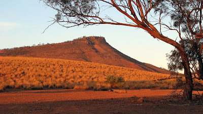

Sunrise on The Dutchmans Stern

From Quorn, I cycled back along the bitumen road towards Port Augusta. The night before, while driving to my campsite, I had assessed how this morning ride would go. The last 5km would be almost entirely downhill and the start would be flat, however the middle section would by mildly uphill. Along a country road though, that uphill can seem to last forever. After resting a couple of times when I thought I was still on the flat section - but was in fact on the uphill section - I made it to the downhill section. I was aware that one can't make a very good assessment of hills whilst driving compared to the assessment one makes whilst cycling.

With my bike stored beneath a bridge on the Heysen Trail, I set off on my hike, up the hill to the ridgetop where I would later get a little misled on.

Once I reached the railway, I came across some sheep and lambs that had escaped the adjacent paddock. A tourist train was coming, I could tell this because of the collection of cars and people armed with cameras aimed at the railway that I could see at a distant level crossing. The sheep saw me, and started running away from me, to stop a safe distance and munch on grass again. Inevitably, I would come closer, and they would run on. This wasn't going to go well though, because the people, the cars and road lay ahead and on the right side, and there was a train coming from somewhere behind. Eventually the sheep chose to run onto the railway, where being animals and dumb, they then followed the railway. After much indecision, they left the railway choosing the road as their preferred fate. Of course that didn't last, they soon returned and ran across the railway - indeed back in my direction, evidently I wasn't quite so threatening compared to the other new threats - with a train just metres from them.


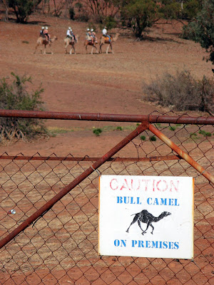
The first section of this day’s hike was good, I quite enjoyed the views, and didn’t really mind getting lost, given all the landmarks. The remaining two thirds of the day’s hike was ok, but pretty flat just following the railway. At one point though I came across a sign on a gate warning of bull camels. What did that mean? Later, when I heard sheep chatting away – this isn’t the first time I have seriously thought I heard sheep chatting and it turned out to be people – I came across the said camels. I think the sign mislead me, I was expecting to have to beat off a camel with a stick – hardly an issue though when the camels are being led by a guide and ridden by tourists.


Saturday night I moved campsite to beside the creek, a spot I couldn’t see in the dark the night before. There was no camping permitted inside The Dutchmans Stern Conservation Park – something I had anticipated. Camping is permitted beside the hiking hut, but this normally has no car access. The creek bank was good though, another awesome sunset.


Sunrise on The Dutchmans Stern

Sunday I did the second hike from Quorn to The Dutchmans Stern. Again, the cycling was easy – almost entirely downhill - it was more an issue of braking rather than peddling. The hike only took me two hours to complete, and initially I had planned to incorporate a loop walk around The Dutchmans Stern, but I didn’t feel that great and was eager to get back home early, being a four hour drive back to Adelaide.

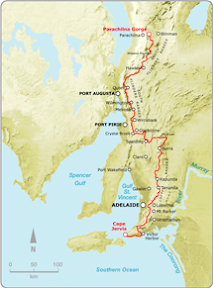
With this catch-up hike complete, I now have only 1 more catch-up to do, scheduled with some friends for June. I have another 6 hikes to do to close the gap between Mt Crawford and Webb Gap (near Burra) so I can complete the entire trail at Parachilna Gorge on August 16 this year. I’ve got dates and people scheduled for all these too, except one, which will be easy to do sometime late in May.


View photos as full screen slideshow


Stats:
Saturday:
  • Distance: 16.8km
  • Start time: 9.00am
  • End time: 12.00pm
  • Moving duration: 3h 20m
  • Stationary duration: 35m
  • Moving average: 5.0km/h
  • Overall average: 4.3km/h
  • Max speed: 11.3km/h

Sunday:
  • Distance: 9.1km
  • Start time: 8.00am
  • End time: 10.10am
  • Moving duration: 1h 47m
  • Stationary duration: 22m
  • Moving average: 5.1km/h
  • Overall average: 4.2km/h
  • Max speed: 10.0km/h

Thursday, April 17, 2008

Exactly how long is the Heysen Trail?

Estimates vary as to exactly how long the Heysen Trail actually is, although it is generally accepted that the trail is approximately 1,200km long. Is this really a good assumption to make though in calculating my percentage done and remaining?

This blog entry is tediously boring if you don't care how long the trail is. Really, what is the difference between whether it is 1,110km long or 1,200km long? Whichever it is, I and many others will walk the entire thing regardless. Don't say I didn't warn you... (although there is a short story about how someone walked 208 miles all the while measuring the distance with a short chain).

I've been keeping a tally of how much of the trail I have walked thus far - 740km, and have been regularly comparing this to the total trail length to see how much of a percentage I have achieved, and how much of a percentage I have left. I've accepted it as 1,200km, however now as I near the end, I don't want to have 10% still remaining on my last walk, only to discover 20km later at the trail head that the trail is shorter than 1,200km, or indeed longer!

Some sources claim the trail is 1,500km long - noted though only a few sources, few of which can be considered reliable. Some state this as the total distance including hills, ie the total steps taken - but this is simply not how you measure distances. Distances are measured from point A to point B via the given path assuming the land is dead flat.

The official guidebooks (published by the government Department for Environment and Heritage) give the distance each chapter covers, and this figure totals between 1,074km and 1,089km. Quite a bit smaller than the 1,200km they claim elsewhere in the introductions to the two guidebooks. However, I noted that some chapter estimates seem too low, particularly the last few chapters of the second guidebook.

There are spur trails and alternate routes along some sections of the trail and some people have used this to explain the disparity in the trail lengths.

John Chapman (www.john.chapman.name/sa-heys.html) seems to have devoted quite some time to determining how long the trail is, deciding the trail is 1,144km long. He refers to two articles that appeared in the Friends of the Heysen Trail magazine and the Adelaide Bushwalkers' magazine that stated the trail to be 1,060km long (the claim isn't referenced with magazine issues/dates). He arrived at 1,144km by using two potentially reliable sources for 2/3 of the trail, and measuring the remaining 1/3 using maps. Assuming the two sources are reliable, the method for the remaining 1/3 will not have been as accurate. However, it does seem to indicate that the 1,200km figure is inflated.

I do have access to a GPS survey, apparently undertaken in 2000 by some university students surveying the entire trail. This file, infinitely more accurate than other sources, measures the trail as 1,175km in length, including spur trails and alternate routes. Using this data, the spur trails and alternate routes total 65km, so depending on which of the alternate routes you use (I favoured the ones I walked) this gives the total trail length as 1,110km. It should be noted though, that there have been numerous re-routes of the trail since 2000, although I would largely expect that in the give and take they would more or less equal out.

It seems very reasonable to me to use this 1,110km figure as the length. I had one further check to make to confirm it's reliability. I had determined that to date (23 April 2008), I had walked 740km of the trail. The figures used to calculate this come from my own GPS unit distances from each walk, and before August 2007, other people's GPS unit distances. With other people's GPS distances, I've tried to keep this as true as possible by rounding both down and up (within 0.5km) to try and keep an accurate overall figure.

Using the GPS survey, I calculated the length of my remaining walks - which amounted to 369km. Hesitantly, I did some sums: 1,110km minus 369km would equal the amount already walked, which in this sum was 741km - just 1 kilometre off my accumulated total of what I have walked. I was quite pleased that the sums added up so well - at first glance this double-check confirms the 1,110km length from the GPS survey. It does use 33% of that same GPS survey (ie the bit of the trail not yet walked) in the proof sums so probably can't be used as definitive proof, but I hope that as I walk the estimated remaining 369km, my own GPS unit will confirm this figure - hopefully to be 1,110km, plus or minus 1%? Which would be 1,099km to 1,121km. I'll report back in August this year my findings (if I still care). Of course, as already noted, re-routes might affect the overall trail length within a small percentage.

In the meantime though, and without going to the length Richard Norwood went to in 1633 to determine the size of the earth (he spent two years walking the 208 miles between London and York, all the while measuring with a short length of chain), I can use 1,110km figure to calculate my trail percentages, and hopefully not have to make any adjustments to that percentage as I near the end of the trail. I'm quite looking forward to getting into the nineties percentage points! So to date, I have completed 66% of the trail.

Note: the original GPS survey file is 17MB, so I can't offer it up here for cross-examination. It has however formed the basis of the KML file used in the Google Maps on the Friends of the Heysen Trail website.