Sunday, June 24, 2007

Ocean Over the Sand Dunes?

Kyeema Conservation Park to Dashwood Gully Road
Southern Guidebook, Maps 2.8-2.10

Lots of forest today. Or perhaps more accurately, what was once forest. Now people live in that forest, sleep on it, and put their trail marker signs on it. What I mean is felled forests, the timber long gone and made into building materials and products, all that was left were some stumps, a few areas of fresh plantings, and lots of sandy tracks. Climbing a couple of undulations - yes undulations, not hills - it was so sandy it felt like we would reach the top and see the ocean and smell the salt air. Alas, no ocean to be seen.


We saw forest too, the living variety rather than the cleared. Today we mainly followed tracks through the forests. We did see a hot dog stand. Seriously. Out there in the boonies, amongst the forest trees, on a wide track. Yep. Oh, but to be more accurate, there were many campers around it, and horses, cars, horse floats and so forth. A weekend horse riding event of some sort.

I've graduated to the fast group. I think my friends in the second group are upset. I don't think they will accept me back now. I've never walked in the fastest group in End-to-End 3 before, I don't know why particularly, just that I didn't during 2006, so I didn't think to in 2007. But of course, now I well know, without any knee probs and with improved hiking and general fitness, fast is my style. Just to let you guys on the outer in, with 100ish people on this walk - indeed 120 today - this allows for that 120 to be divided into 4-5 smaller manageable groups. They all set off at different times, so they can stay separate. So obviously, a fast group is sent forth first. Today, we had about 15 in our group, and we set a good pace. But it was an easy walk, 19.5km, with almost no hills whatsoever. Seriously, a couple of mild undulations, but not hills. We were done by 1.45pm.

  • Distance: 19.5km
  • Time: 4.5 hours or thereabouts
  • Gradient: flat
  • Terrain: mostly tracks, some sandy


Tuesday, June 19, 2007

The Lavender Federation Trail

Just a 15km hike, pretty flat, not very interesting, a few tracks. Well, that's what we were led to believe. Perhaps George Adams was trying out some reverse psychology. Yes, it was pretty flat, yes, it was only 15km, yes, it was predominately tracks, but no, it wasn't boring.


Check out this blog entry on my
Lavender Federation Trail blog.


Re-created, the photo from the front cover of the offical map

Monday, June 11, 2007

Know Your ABC's?

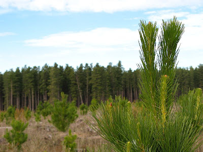
Wirrabara Forest (old nursery) to Block Nine Road
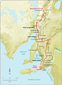
Northern Guidebook, Maps 2.6-2.7

Do you know your abc's? I don't wish to name names (obviously), but some of us don't seem to. Each map of the guidebook shows a gradient profile along with the map, with alphabet letters to mark ridges and troughs. "No, no, surely we are here, at 'H'." No, no, no - ever so hopeful. 'H' marked the top of today's highest peak. We were only, well barely, at 'E'. Which left 'F' and 'G' still to pass, yet alone the long climb to 'H'. Then of course, there was the discussion about 'H' being the last hill. Well yes, kinda, the last significant hill would be more accurate. We still had to change maps, with numerous small hills - or undulations shall we say - before we made it to the next map, and yet another 'H' marking another peak. Although, I must say, this was, yet again, another long hill. A nice climb though, off of the ridge fire tracks we had been following for the past several days, and along a single file trail passing beside a creek. We had already had some rain, along the long ridge in the early arvo, immediately after lunch, but as the day wore on, so did the rain - getting heavier with each shower. By the end of the day's walk, in the pouring rain, we left another fire track to head up a hill - the fire track passed off along a contour seemingly in a different direction. But no, down the other side of the hill we rejoined the same fire track, pretty much at the same altitude as we had left it. Ha ha. Nice one Terry.

Today marked another curious moment. "Wow, I will be able to comment on your cooking after I have eaten this cookie you baked," Elizabeth said. Um, well, no, actually, even then you won't be able to comment on my cooking. And no, please don't shame your family name like that other person on the walk that suggested that I had purchased the cookies in a shop. Absolutely not! This was a secret recipe, handed down from my mother's mother, brought out on the treacherous seas from England. Using Colonel Light Garden's eleven secret herbs and spices - all I can share is the dried strawberries, a key ingredient. They came off the dried strawberry tree of course, the one in the old orange orchard we came by on the first day's hike. It had been my turn to provide the silver platter - a long standing tradition of the End-to-End 2 group, and one which I shan't go into great detail here, or indeed any detail at all. Since Hilary is taking her turn at the silver platter next month, and due to popular request, I have decided to bestow upon Hilary the recipe, including it's finer points, so we may enjoy the cookies again next walk. Various people, and they shall not be named here, came to my rescue this weekend. I shall not entertain any more discussion on the matter, you know who you are, and those that know me well know my incredible gift of memory so you guys can put two-and-two together.

I can't remember much more. Um, it rained, but it was all good. It wasn't cold or windy. Someone took photos of ants superimposed over people's faces. Mmm, good look that. Apparently ants appear in great numbers before rain, and then retreat once the rains come. What I didn't know was that they retreated into camera lenses for protection against the rain. Mmm... nothing else to mention. We probably gave Russell too hard a time though, but hey, welcome to SA and our club. Everyone welcome, do join us, we have no problem in pointing out any of your shortcomings. It's a burden bestowed upon us. A gift you might say.

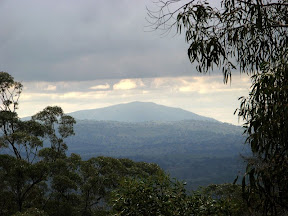
Mt Remarkable looms, not for the next walk in July, but in August. Thirty steep kilometres!

I'd worked up an appetite today though, stopping off at both the Stone Hut bakery (fyi Stone Hut is a town) and the Golden North ice creamery in Laura on the drive home. But you don't care about that. That bakery though, it's akin to the Port Elliot bakery. If you ever pass by - stop. If you ever drive to the central Flinders, maybe go via Clare, then you can pass by - and stop for a few moments and enjoy the good bakery food.


  • Distance: 19km
  • Total time: 6.5 hours


Sunday, June 10, 2007

Lines in the Sand

Beetaloo to Wirrabara Forest (old nursery)
Northern Guidebook, Maps 2.4-2.6

It was a tough walk. Some people, and at this point it would be worthwhile to retain some anonymity, were eager hikers today, walking far ahead of the others. Now the culture of this hiking club is all about walking at your own pace, however one should always stop to regroup at fences, gates, junctions etc. However, there just weren't many of these today, so the group got quite spread out as we each tackled the seemingly endless peaks and troughs. Our goal today was the tv tower on top of The Bluff, a distinct landmark in the South Flinders Ranges. We followed the ridge leading from the start of the Flinders Ranges, northwards. But each peak revealed yet another trough and peak, seemingly always falling short of the looming tv tower. As it turned out, the tv tower was enormous, and nearby were no less than three other towers, all dwarfed by this mammoth tower. So yes, back to those lines in the sand. They became a necessary control measure at these regrouping points. Us fast ones - opps, I mean, um, those fast ones - would spend some time waiting for the rest of the group to catch-up. Being eager hikers, they were keen to set off again, often not allowing those slower paced ones time to catch their breath. Normally, one would wait for the walk leader to start off again, but that's quite hard to do when you are so eager to keep walking! So eventually, Jerry was forced to draw a line in the sand at one of these regrouping points, which we were not permitted to cross. Russell, despite being the newbie in the group, thought nothing of crossing, sorry, accidentally falling, over the line. Sigh... so much to learn.


A long hike today, some 20km, difficult, but still fun. Lots of views over Port Pirie and the Spencer Gulf to Whyalla. After The Bluff, we had a steep hike back down to Wirrabara Forest. As predicted, by the time masters, Leonnie and myself, oh so humbly, we arrived at the appointed time of 5pm - just 15 minutes shy of sunset.


  • Distance: 20km
  • Total time: 7 hours


Saturday, June 09, 2007

Colouring-in Between the Lines

Bowman Park to Beetaloo
Northern Guidebook, Maps 2.1-2.3

Russell joined us for the first time today. He was late, let the record show. Yes Russell, it does indeed take more than two hours to drive from Adelaide to Laura. But to be fair, he has only been here in Adelaide for a couple of months, having moved down from Brisbane. I've got one word for you Russell - whereis.com.au. Anyway, looking rather relieved, he did eventually find us at Bowman Park, near Crystal Brook, at the start of today's walk. Hilary took him under her wing, carefully instructing and guiding him over the weekend in the art of correctly colouring in your guidebook - the record of your achievements along the Heysen Trail. Hilary certainly is the master of this, carefully packaging her guidebook in plastic, so those rains we had on Monday's walk didn't smudge and wash away all that hard work. It is a fine art, one must select the appropriate colours, not just any old highlighter will do. One must also ensure that each subsequent day uses a different, and just as appropriate colour. Myself and Hilary were quite concerned one night, unable to recall the distance we had walked, which could have resulted in a rather a sleepless night, Leonie came to our rescue and was able to put our minds at rest by phoning around amongst the other hikers to find an accurate recording of the distance traveled. These important facts are all part of the colouring-in of one's guidebook. Whilst Leonie spent some time ridiculing us about our colouring-in, more than one of us have caught her out through her carelessness - there has been the odd finger stained with a mark from a highlighter. There seems to be no doubt that she is a closet colourer.

Today we finally entered the South Flinders Ranges. I think I have claimed that before, but this time it is true. We hiked alongside a creek, and once we had decided upon a nice spot to rest for a quick snack, we settled down. However Bev did not approve, and we were forced onwards to find a suitable spot with logs to sit on. Though, I shouldn't diss Bev (yet I just did), with several others she came to my rescue on Monday's hike. But more about that later.

Not many photos today.


  • Distance: 16km
  • Total time: I can't remember