Walkers Follow Ridge
I was just thinking how well marked this section of trail was when I got lost. Just a little lost though, looking at my map and interpreting the contour lines I walked on, following the ridge line, soon passing another marker which stated "Walkers Follow Ridge". But sure enough, yup, I soon lost the trail.
Woolshed Flat to Quorn to The Dutchmans Stern
Northern Guidebook, Maps 3.8-4.2
Frankly, "Walkers Follow Ridge" sounds easier said than done. I mean, all well and good, but one needs to keep a good lookout for the marker that is going to lead you off the ridge. I found this one, but even though there were now lots of markers to lead me down into Pichi Richi Pass, there weren't quite enough for me (or I was too stupid for how few markers there were?). I soon got lost, the trail indistinguishable from the rocky landscape. Although, a fairly good spot to get lost, lots of distinct landmarks: Pichi Richi Pass on one side, containing a road and railway and a couple of distinct dirt roads, and Devils Peak and Mt Brown beyond. And I had my GPS, true. But lost I got, I knew where I needed to be and figured at some point I would wander across the trail and see it again, which of course I didn't. I found the trail again when it met up with railway.
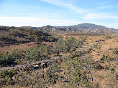
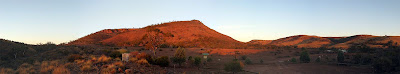
Pichi Richi Pass with Mt Brown beyond
I was doing a catch-up walk that I missed late last year, when I had been training with Tim for the 50km Trailblazer event. I had 26km to cover, divided into two days. Short hikes. I parked my car in Quorn on Saturday morning, having got up with sun after camping in some random roadside clearing near the entrance to The Dutchmans Stern Conservation Park. Beautiful sunrise, so incredibly red.
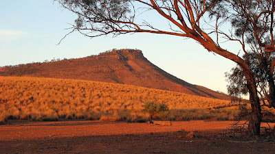
Sunrise on The Dutchmans Stern
From Quorn, I cycled back along the bitumen road towards Port Augusta. The night before, while driving to my campsite, I had assessed how this morning ride would go. The last 5km would be almost entirely downhill and the start would be flat, however the middle section would by mildly uphill. Along a country road though, that uphill can seem to last forever. After resting a couple of times when I thought I was still on the flat section - but was in fact on the uphill section - I made it to the downhill section. I was aware that one can't make a very good assessment of hills whilst driving compared to the assessment one makes whilst cycling.
With my bike stored beneath a bridge on the Heysen Trail, I set off on my hike, up the hill to the ridgetop where I would later get a little misled on.
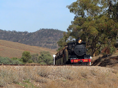
Once I reached the railway, I came across some sheep and lambs that had escaped the adjacent paddock. A tourist train was coming, I could tell this because of the collection of cars and people armed with cameras aimed at the railway that I could see at a distant level crossing. The sheep saw me, and started running away from me, to stop a safe distance and munch on grass again. Inevitably, I would come closer, and they would run on. This wasn't going to go well though, because the people, the cars and road lay ahead and on the right side, and there was a train coming from somewhere behind. Eventually the sheep chose to run onto the railway, where being animals and dumb, they then followed the railway. After much indecision, they left the railway choosing the road as their preferred fate. Of course that didn't last, they soon returned and ran across the railway - indeed back in my direction, evidently I wasn't quite so threatening compared to the other new threats - with a train just metres from them.
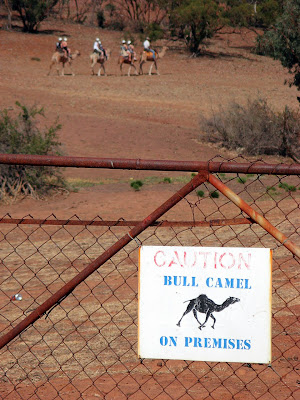
The first section of this day’s hike was good, I quite enjoyed the views, and didn’t really mind getting lost, given all the landmarks. The remaining two thirds of the day’s hike was ok, but pretty flat just following the railway. At one point though I came across a sign on a gate warning of bull camels. What did that mean? Later, when I heard sheep chatting away – this isn’t the first time I have seriously thought I heard sheep chatting and it turned out to be people – I came across the said camels. I think the sign mislead me, I was expecting to have to beat off a camel with a stick – hardly an issue though when the camels are being led by a guide and ridden by tourists.
Saturday night I moved campsite to beside the creek, a spot I couldn’t see in the dark the night before. There was no camping permitted inside The Dutchmans Stern Conservation Park – something I had anticipated. Camping is permitted beside the hiking hut, but this normally has no car access. The creek bank was good though, another awesome sunset.
Sunrise on The Dutchmans Stern
Sunday I did the second hike from Quorn to The Dutchmans Stern. Again, the cycling was easy – almost entirely downhill - it was more an issue of braking rather than peddling. The hike only took me two hours to complete, and initially I had planned to incorporate a loop walk around The Dutchmans Stern, but I didn’t feel that great and was eager to get back home early, being a four hour drive back to Adelaide.
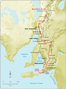
With this catch-up hike complete, I now have only 1 more catch-up to do, scheduled with some friends for June. I have another 6 hikes to do to close the gap between Mt Crawford and Webb Gap (near Burra) so I can complete the entire trail at Parachilna Gorge on August 16 this year. I’ve got dates and people scheduled for all these too, except one, which will be easy to do sometime late in May.
View photos as full screen slideshow
Stats:
Saturday:
| Sunday:
|
![]()

No comments:
Post a Comment