A Long Hike
Myponga to Mt Compass
Southern Guidebook, Maps 2.4-2.6
A long walk for the first walk of the season - 21.8km. After 3 days of rain, a day with lots of brief showers, but no wind and about 20C. Tiring stuff.
Myponga to Mt Compass
Southern Guidebook, Maps 2.4-2.6
A long walk for the first walk of the season - 21.8km. After 3 days of rain, a day with lots of brief showers, but no wind and about 20C. Tiring stuff.
Posted by
Jez
at
4/29/2007 07:42:00 PM
0
comments
![]()
Labels: 2007, End-to-End 3
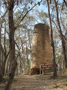 Did some walks (too short to call them hikes) at the Old Echunga Diggings at Chapel Hill on Diggings Road, Echunga, and at Jupiter Creek. Both are gold mines of the 1850's and 1860's. The Heysen Trail and the loop walk at Jupiter Creek share the same trail, the Heysen Trail passing by 1869 Beatrice Chimney and parallel to the 1930 New Phoenix Tunnel. I walked through the 80m tunnel - with a torch - and climbed the ladder in the shaft at the end. I'm not too fond of small tunnels (well, small spaces in general) but this one was easy. Both mining fields are covered in shafts, particularly Chapel Hill where the shafts are noticeably smaller in both radius and depth, being about 10m down to gold. The Jupiter Creek shafts are fewer in number, yet much larger and deeper (up to 50m deep).
The Jupiter Creek loop walk can be found in the Sunday Mail's publication WalkSA (2006), pp 42-43.
The following is condensed from the Battunga Country website:
www.battunga.org.au/towns/jupiter_creek.htm
A map of the area is also available on their website:www.battunga.org.au/maps/Region-map.htm.
Old Euchunga Diggings (Chapel Hill)
After the discovery of gold in Victoria, many South Australians left the colony in search of the elusive “lucky strike”. In an effort to stem this mass exodus, the South Australian Government offered a £1,000 reward for the discovery of a payable goldfield. The first claim for this reward was made for gold discovered at Echunga.
By the turn of the century, with an area extending from Chapman’s Gully to Jupiter Creek, the Echunga Goldfields had become South Australia’s most productive, though few made a fortune. The goldfields could not compete with the richer fields in Victoria and by 1853 the goldfields were described as being ‘pretty deserted’.
Small amounts of gold continued to be found over the years and there was a renewed interest in the old diggings when there was a change in the gold standard and prices rose during the depression years of the 1930s.
The total production of the Old Echunga Diggings is estimated to have been around 3,100kg.
Jupiter Creek
The second major diggings in the Echunga area opened up after gold was discovered at Jupiter Creek in 1868. By September 1868 there were about 1,200 people living at the new diggings and tents and huts were scattered throughout the scrub. By the end of 1868 though, the alluvial deposits were almost exhausted and the population dwindled to several hundred.
As with the Old Diggings, small amounts of gold continued to be found over the years with three distinct periods – from 1884-1890s, 1904-1907 and during the 1930s.
The Diggings Today
Since being ravaged by bushfires, the diggings are gradually being reclaimed by natural bush and these once bustling areas are now deeply silent. Nevertheless some relics still exist. Visit the old diggings at Chapel Hill and follow the sign-posted path to find some of these relics then on to Jupiter Creek to follow the Heritage Trail which interprets successive phases of mining at that site. It includes the 1869 chimney associated with the Beatrice Gold Mining Company, sluicing dam (1906) and the New Phoenix Tunnel (1930).
Both sites are registered as State Heritage Items.
Posted by
Jez
at
4/22/2007 06:02:00 PM
0
comments
![]()
Labels: 2007, Off the Trail
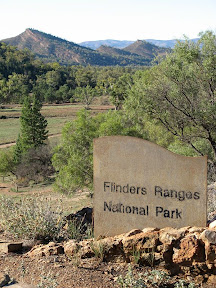 Some photos of a camping trip into the Flinders over Easter, camped in Aroona Valley. Not strictly hiking the Heysen Trail, but a weekend of camping and hiking with a couple of friends. We walked a couple of small Heysen Trail sections near Aroona Valley, but also walked through Wilpena Pound to Malloga Falls in Edeowie Gorge, and to the Blinman Pools.
Here are the best 44 photos from the 300 odd photos taken (thanks to Tim for some excellent photos and photo taking expeditions). Might return later to write some funny comments and stuff...
Here I am back... I really should have had some idea. I had been here before in the Flinders - for the first time - just a couple of years ago. We had driven along roads then where it was difficult to determine whether you were driving in a creek or on a road. It was 11.30pm at night, we had left the city at 5.15pm on Thursday keen to get out camping so we could enjoy every day of hiking. So like I said, it was late, and we still hadn't made camp, we were slowly driving along a creek - or road - or whatever in our little Ford Focus. Tim skillfully steered the vehicle around the rocks, whilst Kate skilfully provided warning and varying "eeks" as feedback to Tim's driving success. I hadn't been on this particular road before, but even in the dark it was spectacular - Brachina Gorge. If you like rocks this would be heaven. I think rocks are pretty. Tim later declared the Flinders as a diverse and rugged part of SA - all good. That's a good evaluation I think. Stunning geography, sunsets and camping.
Anyway, having paid our entry and camping fees at the self registration point, we snuck past the Campground Hosts. We had chosen to set up camp in Aroona Valley because of it's close proximity to various walking trails. We arrived past 12, and set up the tent without the fly or pegs, keen not to wake other campers. Kate pointed out that my method of closing the car doors was not consistent with that intention... Next morning I took some sunrise photos, exploring the ruins of Aroona homestead. We finished setting up the tent and set out for a hike along part of the Heysen Trail. I've lost my map so I'm not quite sure what the loop trails we hiked were called, but we saw some really impressive stuff - including huge spiders - and got a bit lost. We walked about 11km, spending the arvo resting.
 The next day we hiked through Wilpena Pound to Malloga Falls in Edeowie Gorge. Spectacular stuff. Being 23km, hikers were advised to allow 9 hours return. We did it in 6 hours. We were advised the track was unmarked, but it was marked with the same markers as elsewhere, marked every 200 metres, but piles of stones, footprints and arrows in the sand helped us find the way through the overgrown foliage. Kate really found her strength here, both Tim and I being taller seemed to cop more of the foliage in our faces. We were also informed to be wary of falling hikers from the clifftops above. We didn't see any. The falls were dry, just one stagnant pool. Found some disorientated hikers on the way back. We kindly informed them it was "a mere 8km" in the opposite direction back to the Pound entrance.
The mentally awful songs - not one finishing before another started - drove us off the information centre patio immediately after our icecreams were finished. Sawing our one bar of soap into portions we paid for a hot-warm-cold-warm-cold shower in the Wilpena campground - nice. Kate's shower was hot-hot-hot. Go figure. Regardless, rather appreciated the new smell (or lack of bad smell). 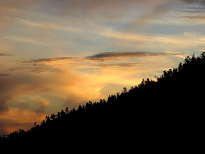 Drove back to camp along the Bunyeroo scenic drive whilst the sun set - some cool photos and a resolution made for Tim and I to return next morning for sunrise. Tim reckoned the colours would reflect more spectacularly during sunrise - he was right. Clever maths man. We left camp at 5.30am and got some pretty cool photos. It's fun to have a photo partner. Loving my new camera, so much better than my old one. The following morning we climbed up a hill in Aroona Valley and Tim got some top shots of the sunrise on the Heysen Ranges.
 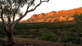 Must've been a good idea as we were joined by 3 other people for the same purpose, who later seemed to be contenders as spectators for Tim and I to shower under a fire hose fed by the local spring. Got to admire one of them though, getting up early, then climbing the hill to take photos with her broken camera, quite unsure if her photos would work. I reassured her it looked like just a cracked LCD screen, and she then seemed happy that the people at the photo shop would still be able to develop her film (in her digital camera!?!)
 Over confident from our previous day's quick walk, we thought today's 5 hour hike to the Blinman Pools would be an easy 3 hours. It was already late in the morning. We thought we were close to the First pool, 5km in, when we reached the half way sign. Our confidence was shattered, and we were pretty tired from the previous day. Apparently 8-10 hours sleep wasn't going to save us. We psyched ourselves up to finish the walk - I found solace in eating, the others by gloating that later they would eat as I enviously watched on having already consumed all my rations. Whatever, there's nothing wrong with slurping a freddo frog out of it's wrapper like an ice stick (it was like 30 degrees). Near one of the larger and more inviting pools we found a family lost in giggles, seriously - they were. Standing behind a tree was an embarrassed girl tightly clinging to the towel around her, I think she felt quietly confident no-one else would be coming along. Beyond this pool we found that the official First and Second Pools weren't as inviting. The Second Pool was drying up, the First fed by a spring but still not so inviting. Tim tested out the durability of his new metal water bottle by dropping it from a cliff. It passed. Eating an icecream later at the shop in Angorichina Village we found a much better map than the rubbish one we had - one that would have allowed us to take short cuts on the way back!
 Tim managed to re-establish his love for photographing kangaroos, a given both Kate and I had experienced long ago in Deep Creek. He got some good photos though, roos are such funny creatures, we got very close once when we stumbled across some unawares.
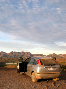 Enjoyed some good food, good wine, good beer and some good times. A very warm weekend, high 20's. Kept up our uncanny matching clothes to the end. The Focus proved to be an excellent car, I'm sure in part to Tim's skillful driving and Kate's always at hand feedback, but we saw many 4WD drivers being more hesitant with their cars. Typical. We should have had the right to swap cars. We drove home in 6 point something hours, a good run compared to our 7.5 hour drive there. Apparently previous clogged Pt Wakefield Road Easter experiences caused everyone to be fraidy cats and stagger their driving throughout the day. Nice. The jerks still drove at their regular time though. Disappointed to see survey markings out in preparation to seal the dirt road from Wilpena to Blinman, it can only mean the driving will get worse, and take a little of the magic away from the Flinders and the quaint town of Blinman. This hiking weekend renewed my love of hiking. I was thinking of not continuing hiking the Heysen Trail this year. I dunno, whatever. But I'm keen to hike and as always, camp.
Posted by
Jez
at
4/09/2007 08:53:00 PM
0
comments
![]()
Labels: 2007, Off the Trail
| Trail completed to date:
Estimates of the length of the Heysen Trail vary, see the trail length discussion (verging on a tedious bore). |
|
A note about the GPS maps appearing on this blog. Prior to September, 2007, all Google Maps are mash-ups, drawn on-screen. Initially, I favoured the satellite image as the determining where to draw the trail, but later I started to rely on the map view to determine where to mark the track - this being more accurate when satellite images would later be updated (the map and satelite often don't closely match up). As of September, 2007, all maps are generated from a GPS unit, so can be considered accurate (particularly when looking at the map view). Of course that doesn't stop me from wandering off the trail... |
Intro |