A Bloody Hot Walk
Bloody hot walk. But we bridged the gap between Mt Crawford Forest and Kapunda, via the Barossa Valley
2 hikes: Pewsey Vale to near Greenock and onwards to Kapunda
Southern Guidebook, Maps 4.2-4.7

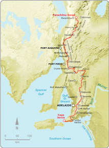
Today we did a catch-up walk, or a walk we are yet to miss. Thing is, both Hilary and myself plan to finish the Heysen Trail on August 16 this year at the trailhead at Parachilna Gorge. To do this, we have a few of the End-to-End 3 walks that we need to walk before they do, to ensure we finish the trail at Parachilna Gorge and not late next year at Webb Gap (near Burra). So we have 9 walks to bridge, between where End-to-End 3 finished last year, and where they will finish next year. 3 we will do with End-to-End 3 as scheduled, in May, June and July. The next 3 we did over 2 walks, as detailed here, to Kapunda. I then have to walk from Kapunda to Peters Hill, and then we will join Bev to walk 2 days from Peters Hill to Webb Gap in early May.

So we did these two walks. Although the Heysen Trail is closed, the first walk, and most of the second walk, are open year round because they are in forests, conservation parks or on public roads. We had double checked this with the Department for Environment and Heritage before setting out, but between Boundary Road, just beyond Greenock, and Hankel Creek Road near Kapunda, the trail is definitely over farmland. They might be road reserves, but very much not roads. But we had checked with the DEH and positioned our cars before this became clear.

It was a bloody bloody hot weekend, Saturday was high 30's, and much of the walk was in open sun. The road walking beyond Tanunda was especially harsh with no shade whatsoever. As a result, we set out very early for our Sunday hike, finishing before lunch.

We hiked from the forests of Mt Crawford, over into the spendourly green Baroosa Valley, through the valley into the historic mining town of Kapunda.
View photos as full screen slideshow
Stats:
Saturday
- Distance: 24.9km
- Start time: 9.17am
- End time: 2.55pm
- Moving duration: 4h 26m
- Stationary duration: 1h 11m
- Moving average: 5.6km/h
- Overall average: 4.4km/h
Sunday
- Distance: 21.5km
- Start time: 6.56am
- End time: 11.38am
- Duration: 4h 41m
- Overall average: 4.6km/h


 of
 Completed