Thursday, June 12, 2008

Special places

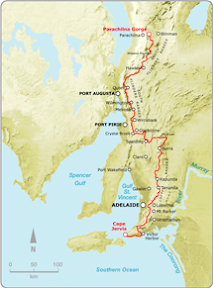
There are a few spots along the Heysen Trail that are very special, and this walk is along one of them - Yourabulla Range.

Jarvis Hill to Old Wonoka
Northern Guidebook, Maps 5.1-5.2


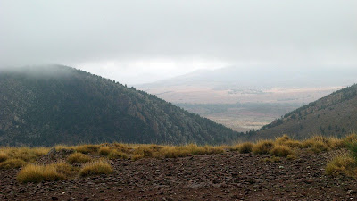
View from Yourabilla Range

There are just breathtaking views from the ranges over the Yilson Valley towards the Yappala Range in the west and The Wide Range and Red Range in the east and Wilpena Pound in the north.

Only 9km today, half along the range, half along the plain.


View photos as full screen slideshow


Stats:

  • Distance: 9.81km
  • Odometer: 101.6km
  • Start time: 9.23am
  • End time: 1.49pm
  • Moving duration: 2h50m
  • Stationary duration: 1h34m
  • Moving average: 3.5km/h
  • Overall average: 2.2km/h
  • Max speed: 7.6km/h

Wednesday, June 11, 2008

The Paranormals

The Normals, the Abnormals and the Paranormals. Today we had a handicapped start, the Paranormals first, followed by the Normals - the deciders of these names - and finally by the fastest hikers, the so-called Abnormals.

Partacoona Road to Jarvis Hill
Northern Guidebook, Maps 4.8-4.11


Like yesterday, the bus couldn't cross Kanyaka Creek, so two 4WDs ferried us the 6km to the start of today's hike - the end of yesterday's hike. It would be a long day - 26km - so the slowest hikers were ferried first so they could start walking.

Suprisingly, us Paranormals didn't catch the first yet slow group until they stopped 6km down the trail, we never even caught sight of them.

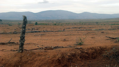
Not a lot to see today, well, the same view all day basically. Lots of marginal grazing land, old and rundown fencing demonstrating just how marginal the land is. A climb at the end of the bus on Jarvis Hill.


View photos as full screen slideshow


Stats:

  • Distance: 26.8km
  • Odometer: 91.79km
  • Start time: 8.58am
  • End time: 4.10pm
  • Moving duration: 5h35m
  • Stationary duration: 1h35m
  • Moving average: 4.8km/h
  • Overall average: 3.7km/h
  • Max speed: 8.9km/h

Tuesday, June 10, 2008

We really are OCD

Due to heavy rains the bus could only make it so far to today's end point, so we had to walk 5km past the bus to ensure we walked that section of trail - then had to return that 5km back to the bus.

Buckaringa Gorge to Partacoona Road
Northern Guidebook, Maps 4.6-4.8


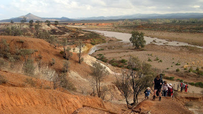
Willochra Creek

Buckaringa Gorge was spectacular - huge surreal rockfaces. Willochra Creek was also a treat, flowing of course, so a tricky crossing and a climb up a rickety ladder.

A few falls today, muddy bums and so forth. The bus ride home was also a bit tricky with muddy roads.


View photos as full screen slideshow


Stats:

  • Distance: 21.5km + 2km
  • Odometer: 64.99km
  • Start time: 9.48am
  • End time: 4.17pm
  • Moving duration: 4h 33m
  • Stationary duration: 1h 55m
  • Moving average: 4.7km/h
  • Overall average: 3.3km/h
  • Max speed: 13.4km/h

Sunday, June 08, 2008

Most effort for least trail distance covered

Today the roads were wet. Our first attempt to reach the trail failed, so we made new plans. Having walked 9km to reach the trail, we made it just 450m along the trail before giving up and returning.

Mt Arden attempt
Northern Guidebook, Map 4.5


The climb towards Mt Arden

We had planned to walk from The Dutchmans Stern to Eyre Depot today, but yesterday due to recent heavy rains we changed it to the second planned day, from Eyre Depot to Buckaringa Gorge. This was so we could do the longest, hardest walk of the week before it got any wetter. Unfortunately it was just too wet for the bus on the muddy track, so after driving 17km from Port Augusta down a track towards Eyre Depot, we turned around. We formed a Plan B, go to the Arganells property - a 4WD, mountain biking and hiking property - to access the trail near Mt Arden, then walk to Buckaringa Gorge.

After three hours in the bus to reach that point, we hiked a short distance before having a morning break in the an old girl guides hall that had recently been moved on site.

We then set off through Hammersley Gorge - this area was just beautiful, stunning indeed. However by the time we had actually reached the Heysen Trail, some 9.5km later, we walked just 450m along the trail before giving up. The walk to the trail was ok, it was in sheltered valleys, but now we were to walk on an exposed ridge for the next 8km or so, it was just too windy and cold. We turned around and returned to the bus.

So we had spent 3 hours driving and 6 hours hiking to hike a mere 450m along the trail. Not much colouring in to be down in the trail guide this day.

The rain had got heavier, and the track wetter as we returned to the bus, so Monday's hike was canceled, pending better weather on Tuesday.


View photos as full screen slideshow


Stats:

  • Distance: 19.3km
  • Odometer: 24.59km
  • Start time: 9.46am
  • End time: 3.41pm
  • Moving duration: 4h 22m
  • Stationary duration: 1h 32m
  • Moving average: 4.4km/h
  • Overall average: 3.3km/h
  • Max speed: 14.1km/h